
globe@humanservicesglobe.com
|
Q: What is The Srinagar-Rawalpindi Way?
A: The Srinagar-Rawalpindi Way is a _____mile/km section of Kashmir Highway between Srinagar, Kashmir and Rawalpindi, Pakistan. |
|
What is the length of the road? What should be the breadth of the road? What is the expected flow of traffic? What type of traffic is expected to flow on this road? What is the weight of each vehicle? What should be the thickness/height of the tarred layer of the road?
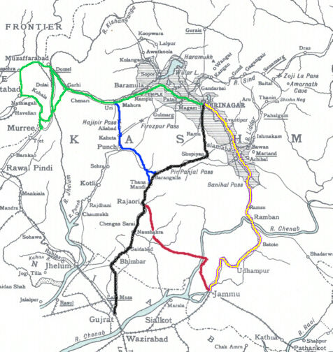
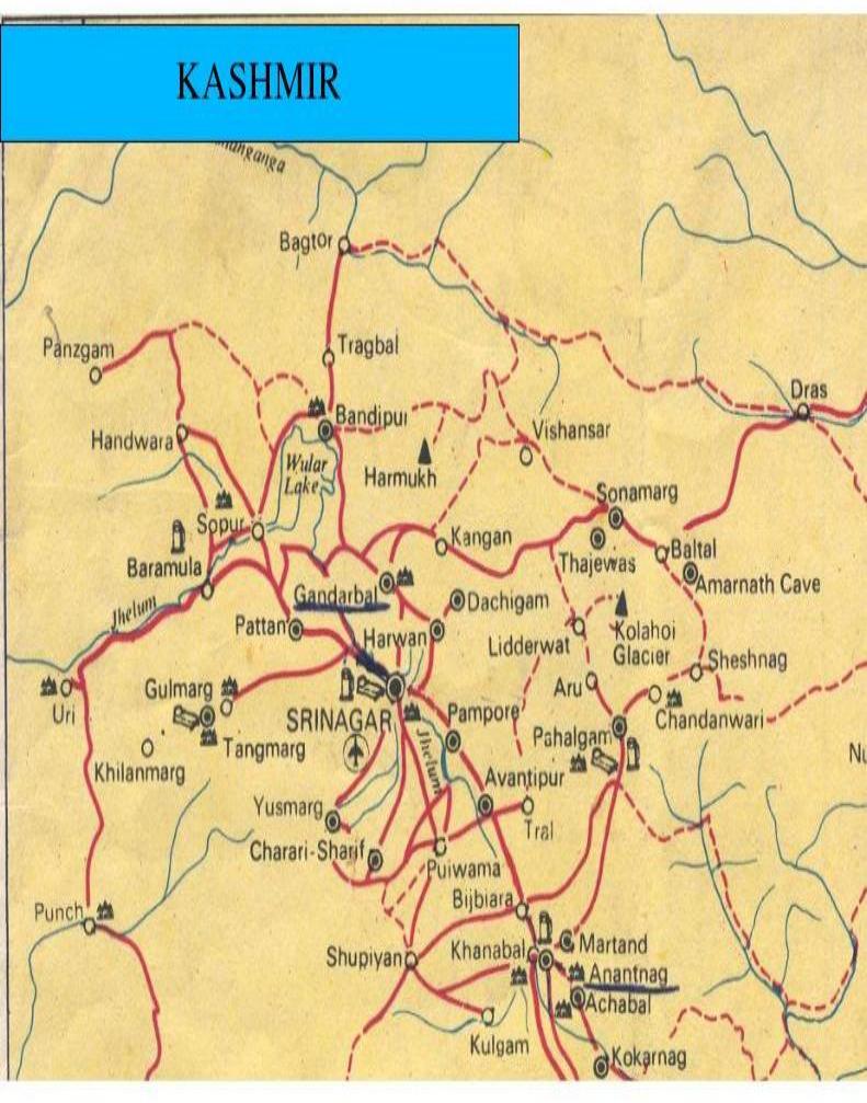
b) Metaled/Re-metaled c) Shingling/ Solling d) Fair Weather e) Jeepable 2. Srinagar-Shopian Road is 53 Kms. long and connects Srinagar, Pampore, Pulwama, and Shopian. 3. Srinagar-Kulgam Road connects Srinagar, Khannabal and Kulgam. It is 71 Kms. long. 4. Srinagar-Gulmarg Road is 29 Kms. long and connects Srinagar, Tangmarg and Gulmarg. 5. Srinagar-Pahalgam Road is 96.5 Kms. long and connects Srinagar, Awantipura, Khannabal, Mattan, Aishmuqam and Pahalgam. From Pahalgam a bridle path leads to Swami Amarnath cave which is 45 Kms. from Pahalgam. On this route, Chandanwari, Sheshnag and Panjtarni stations are worth mentioning. 6. Srinagar-Bandipur Road leads to Shalateng- situated on the Jhelum Valley Road. From Shaltang this road leads to Bandipur. It is 56Kms. long. From Bandipur to Sopore it is 33 Kms. From Bandipur another road leads to Gurez and it serves as a military defence road. 7. Srinagar-Wayal Road is 85 Kms. in lengh. On this route, Anantnag, Achhabal, Kukarnag are worth mentioning. 8. Sopore-Tetwal Road is 95 km, long and connects Sopore, Handwara Trehgam, Chowkibal, Santochangli and Tetwal. From Srinagar to Chowkibal the road is open for both public and military traffic, but from Chowkibal to Tetwal only military vehicles run and the road is closed during winter when there is heavy snowfall. 9. Srinagar-Gandarbal-Baltal Road winds its way across the Anchar Lake passing through Ganderbal where the Sind Nullah enters the Anchar lake. This road connects with many other roads, the important one is Khirbhawani or Tulamula road leading to the well known shrine. The main road passes through the entire valley of the Sind Nullah upto Baltal, the foot of the Zojila pass Beyond Baltal the road leads to Matayan and to Dras. It is 117 Kms.long up to Baltal and from Baltal to Dras it is 45 Kms. 10. Srinagar-Charar-e-Sharif Road has been constructed over the karewa to the southeast. It leads to the well known shrine Chrar-e-Sharif. 11. Srinagar-Leh 434-km. Ladakh Road is 80 Kms from Srinagar to Sonamarg. It connects Srinagar, Gandarbal and Sonamarg, from where. after passing over the Zojila Pass it connects Machai, Drass, Kargal and Leh, the capital of Ladakh Province. From Sonamarg to Leh the distance is 350 Kms. 12. Kargal-Askardu Road is 151 Kms. in length. On the way, Kharalpul, Awiding, Bagicha Talse, Madhopore, Gole and Theggo are worth mentioning. 13. Pulwama-Yus-gogji Pathar Road connects Pulwama, Parkota, New Kalipora, Ramopakherapora, Kanidanwan and Yus-gogjipathar. 14. Khannabal-Kulalgam 17 Kms. 15. Anantnag-Verinag 26 Kms. 16. Srinagar-Tral -Shikargah 45 Kms. 17. Shopian-Kulgam 22 Kms. 18. Shopian-Wuyun-Letapore 31 Kms. 19. Shopian-Bijhebara 31 Kms. 20. Srinagar-Naseem-Pandach 18 Kms. 21. Srinagar-Halwar-Drafama 27 Kms. 22. Srinagar-Aerodrome 11 Kms. 23. Srinagar-Chrar-e-sharif-Yusmarg 47 Kms. 24. Srinagar-Badgam-Raithan 32 Kms. 25. Baramula-Langet-Handwara 29 Kms. 26. Srinagar-Sopore 73 Kms. 27. Srinagar-Sopore-Gangbug 137 Kms. 28. Handwara-Nichhama 21 Kms. 29. Handwara-Magam-Lonawara 27 Kms. 30. Ukherhal-Senawatipul 11 Kms. 31. Srinagar-Panthchak-Lethpora 31 Kms. 32. Srinagar-Baramulla 60 Kms. 33. Muzaffarabad-Rawalpindi 138 kms. 34. Muzaffarabad-Abbottabad 79 kms. 35. Srinagar-Amritsar___ km 36. Srinagar-Delhi ______km
Quazigund to Banihal section (15.25 km) Banihal to Ramban (36 km) Chenanni to Nashri (12 km) Ramban to Udhampur (43 km) Udhampur to Jammu (65 km) Udhampur to Amritsar 38. Srinagar-Bandipora-Kargil-Xinjiang-China Railways Coming Sonn Udhampur-Katra, Katra-Qazigund and Qazigund-Baramulla, Baramulla-Rawalpindi Qazigund-Baramulla section will have 800 bridges. The Qazigund-Baramulla section will have 15 stations. Lalu Prasad. Bad performance. Pakistani Railways. Chinese Railways Would you like to add anything? Do you have any recommendations? Q: How long will the construction take? A: The entire project should be completed by the end of 2008. Q: What was wrong with the highway that needed fixing? A: There were three prime Political, deliberate, unfair issues:Passing lanes will also reduce congestion. Line-of-sight issues are addressed in the construction as well. The over _______ wildlife crossings incorporated into the construction will not only reduce wildlife mortality, but collisions and animal/vehicle collisions will be mitigated. Q: What are the primary improvements? A: The majority of changes aim to improve safety. Wider shoulders, passing lanes, turning lanes, controlling access, wildlife crossings to reduce animal-vehicle collisions, improved sight-distance and one-way couplets will accomplish this goal. Q: Why has it taken so long to begin construction on this project? A: The project was a long time in the planning process because of the extremely context sensitive nature of the area, and the fact that the involved parties initially saw vastly different needs, priorities, and preferences. For many years, the project languished as involved parties were stalemated over Political, deliberate, unfair practices. Q: Why is this project different than other highway projects? A: Political, deliberate, unfair practices. The guiding philosophy for these modifications is to protect cultural, aesthetic, recreational, and natural resources located along the highway corridor and to communicate the respect and value that is commonly held for these resources pursuant to traditional ways. Q: What will the impact of this project be? A: Safety will be vastly improved. Safety analysis forecasts that the construction will result in the reduction of fatalities. Economic efficiency will be better due to increased traffic handling efficiencies of the road and Trade. At the same time, the intergovernmental collaborative process has reshaped same. Q: What role did HSG play in the design of this project? A: HSG has been an equal partner in the design of this project. Q: How is the project being financed? A: The project will be 100 percent federally funded. Q: Will traffic be affected by construction? A: Yes. Enormous resources to making sure that traffic information is readily available to the public and business owners in the area. Information will be available through a variety of sources, including frequent e-mail updates. Two-way traffic will be open through the corridor throughout this project. Motorists should look for blue signage indicating detour access to businesses in construction zones. Q: How do you plan to address safety during the construction of the highway? A: Safety is a concern with all construction projects. Will use all the standard methods and techniques. Q: What kind of delays do you expect? A: Unfair political influence peddling, unfair competition. Road construction projects always impact the traveling public. These projects were designed to minimize the impact as much as possible,enhance trade, but because the new road will occupy much of the existing roadway footprint, construction delays are inevitable. The contractor and Project personnel will continually work to reduce the delays as much as possible. Additionally, contract incentives are in place with the individual construction contractors for speedy and efficient completion. Q: What will this project cost? A: Up to $ or Rs ______ for the entire _____-mile or KM segment, including the Pak section. Q: What kinds of animals migrate in the area? A: Fish, grizzly bear, black bear, deer, elk, moose, pronghorn antelope, painted turtles and many others. Q: How are the construction contracts awarded? A: HSG has followed its standard procedures that award the contract to the lowest bidder. Q: How many fatalities have there been in the last decade on ______? A: (Pending) Q: How many lanes will the road have? A: Four lanes between Srinagar and Rawalpindi. Q: What will the speed limit be? A: 100 MPH in most sections, with speeds as low as 35 MPH in cities. Q: Will homes be relocated as a result of the highway widening? A: Yes. The impact on homeowners has been minimized as much as possible. However, some homes have either been bought in entirety through the right of way process or relocated to accommodate the project. Q: How do we get updates on what's happening with the construction? A: Frequent e-mail updates will be issued as the need arises. Q: Why is the (Baramullah _____) bridge project taking so long? A: We aren't involved in this bridge. Ask Border road organization or Becon. |
Do you have a question?
Can you bring me upto date?
Would you like to add anything?
What is the method of payment?